- By Artist
- A RACINET
- CAPT ROBERT MILVILLE GRINDLEYS
- CAPT.THOMAS WILLIAMSON & SAMUEL HOWITT
- CHARLES D`OLYE CALCUTTA
- CHARLES STEWART HARDINGE
- DANIELL’S ORIENTAL-SCENARY
- E A RODRIGUES
- EMILY EDEN
- EUGENE BURNOUF
- GEORGE FRANKLIN ATKINSON
- HENRY MARTIN
- INDIAN ARMY- HENRY MARTIN
- HENRY SALT
- INDIAN ARMY-A C LOVETT
- JAMES ATKINSON
- JAMES FORBES
- JAMES FRASER
- JAMES FRASER CALCUTTA
- JAMES RATTERY
- JOHN GOULD
- JOHN LUARD
- LT. COL.CHARLES RAMUS FORREST
- MRS S.C BELNOS
- NATIVE INDIAN ARMY
- PRINCE ALEXIS SOLTYKOFF
- PRINCE WALDEMAR
- THOMAS & WILLIAM DANIELLS
- THOMAS JEFFERYS
- THOMAS & WILLIAM DANIELL- DELHI
- W T GREENE
- THOMAS & WILLIAM DANIELL – CALCUTTA
- WILLIAM HODGES
- WILLIAM SIMPSON
- WILLIAM TAYLER
- WILLIAM WOOD -CALCUTTA
- WOOD ENGRAVINGS

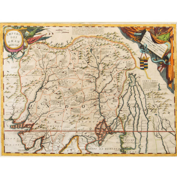
HINDOOSTAN
This is an engraved coloured map of Hindoostan, depicting India with Ceylon. The map was drawn for New General Atlas, 1820 which shows the section of the Ganges and its course through the country in the dry season.
SIZE –19 x 24 in.
EXPORTABLE-No
SHIPPING-Free shipping for all orders within India
CODE NO – M4